


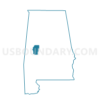
Akron City Hall B, Hale County, Alabama
About
Outline

Summary
| Unique Area Identifier | 521895 |
| Name | Akron City Hall B |
| County | Hale County |
| State | Alabama |
| Area (square miles) | 12.90 |
| Land Area (square miles) | 12.70 |
| Water Area (square miles) | 0.20 |
| % of Land Area | 98.48 |
| % of Water Area | 1.52 |
| Latitude of the Internal Point | 32.81825920 |
| Longtitude of the Internal Point | -87.70162700 |
Maps


Graphs
Select a template below for downloading or customizing gragh for Akron City Hall B, Hale County, Alabama


Neighbors
Neighoring Voting District (by Name) Neighboring Voting District on the Map
- Akron City Hall, Hale County, AL
- Akron City Hall A, Hale County, AL
- Bucksnort, Hale County, AL
- National Guard Armory 4-A, Hale County, AL
- Sawyerville B, Hale County, AL